Top Tourist Attractions in Gopalganj
Gopalganj is a town, municipality, and the administrative centre of the Gopalganj district in Bihar, India. It is situated between the latitudes of 83.54° and 85.56° and the longitudes of 26.12° and 26.39° North. It is bordered on the east by Champaran and the river Gandak, on the south by Siwan District, and on the north by Uttar Pradesh’s Deoria District. The river Gandak, which is fed by tributaries like as the Jharahi, Khanwa, Daha, and Dhanahi, has a large status.
This is due to the District’s rich and alluvial soil. The District benefits from this river in terms of farming and irrigation. The river brings wealth to the inhabitants and contributes significantly to the District’s significance and uniqueness. River Gandak contributes significantly to the District’s economy by depositing high-quality dirt brought in from Nepal.
Best Places to Visit in Gopalganj
- Thawe Temple
- Shri Pitambara Peeth (Maa Bangalamukhi)
- Dighwa – Dubauli
- Husepur
- Lakri Dargah
Thawe Temple:
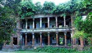
A settlement is located 6-kilometers south of the District Head Quarters, where there is a junction station “Thawe” on the North Eastern Railway’s Masrakh-Thawe section and the Siwan-Gorakhpur loop-line. There is an old fort in the settlement, but its history is unknown. The palace of the King of Hathwa once stood there, but it is now in a decrepit state. An historic temple dedicated to Goddess Durga is located near the Hathwa Raja’s home. A strange tree, the botanical family of which has not yet been named, grows within the temple’s boundary. The tree has grown into a cross. There are numerous legends associated with the idol and the tree. Every year in the month of Chaitra, a large fair is held (March -April).
Shri PitambaraPeeth (MAA Bagalamukhi):
Shri PitambaraPeeth is a well-known Shakti Peetha in Bagalamukhi, located 15 kilometres from Gopalganj in Kuchaikote. Bagalamukhi is one of the ten mahavidyas in Hinduism (great wisdom). Bagalamukhi Devi uses a bludgeon to thrash the devotee’s preconceptions and delusions. The name directly translates to “crane-faced.” The name ‘Bagla’ is a distorted version of the Sanskrit root ‘ValgA.’ She has a golden complexion and wears yellow clothing. She sits on a golden throne in the centre of a nectar-filled ocean teeming with yellow lotuses. Her hat is adorned with a crescent moon. Various texts describe the goddess in two ways: the ‘Dwi-BhujA’ (two handed) and the ‘ChaturbhujA’ (four handed) (four handed). The Dwi-BhujA representation is the more well-known and is defined as the’soumya’ or gentler variant.
She is pictured with a club in her right hand, which she uses to strike the demon while tearing his tongue out with her left. This artwork is sometimes depicted as an exposition of’sthambhana,’ the ability to stun or paralyse one’s opponent in order to silence them. This is one of the blessings for which Bagalamukhi is revered by her devotees.
Dighwa-Dubauli:
A village in the Gopalganj subdivision, 56 kilometres north of Chapra and 40 kilometres southeast of Gopalganj. It is also a railway station on the Chapra – Mashrak section of the North-Eastern Railway. It is an old location with two unusual pyramidal-shaped mounds. These two mounds are located to the southeast of the village, as well as to the east and west of one other.
The western mound is virtually adjacent to the village’s south eastern edge, while the eastern mound is 640 feet to the southeast of the other and close to the road. Each of these mounds is pyramidal in shape, with four corners at the base protruding significantly outwardly, so that a ground plan of one of these mounds would resemble a fore pointed star surmounted centrically by a cone. These mounds appeared to be made of clay, but they were combined with minute pieces of brick and pottery. A round-shaped mound of modest height is located 950 feet to the south of the eastern mound, with a horizontal diameter of roughly 200 feet from north to south and 140 feet from east to west.
There is an old well here. Across the road to the north of the village there is a portion of the mound, which appears as if cut off by the road from the large flat mound, on which the village DighwaDubauli itself stands. These mounds are said to have been the works of Chero-Chai, i.e., of the Cheros, an aboriginal race who seem to have once been powerful in this part of the country, but who now inhabit the hills to the south of the Ganges.
Lakri Dargah:
An old well can be found here. A section of the mound appears to be cut off by the road from the enormous flat mound on which the village DighwaDubauli itself stands across the road to the north of the village. These mounds are claimed to be the work of Chero-Chai, i.e., the Cheros, an aboriginal race that appears to have formerly been powerful in this section of the nation but now lives in the highlands south of the Ganges.
Best Time to Visit in Gopalganj
February is one of the best months to visit Gopalganj, Bihar. Mar: The weather in Gopalganj, Bihar, is pleasant in March.
How to Reach Gopalganj
Reaching District Head Quarter by air, rail and road:
Air:
The nearest airport is at Sabeya, Hathua, 30 kilometres from the district headquarters.
Rail:
A station in Gopalganj connects the District Head Quarter to the rail network (important broad gauge route and a narrow gauge line).
Road:
State highways and roads link district headquarters at Gopalganj to all 14 blocks. National highway (No 28) passes through Gopalganj.
All 14 blocks are connected by state highways and roads from the district headquarters in Gopalganj. Gopalganj is located on the National Highway No. 28.
There is road connectivity from the District HQ to several tourist destinations.

